RunVue 사용 가이드
RunVue Guide: turn your runs into 3D replay videos
RunVue는 어떤 앱인가요
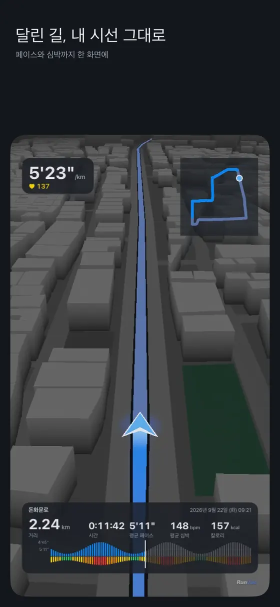
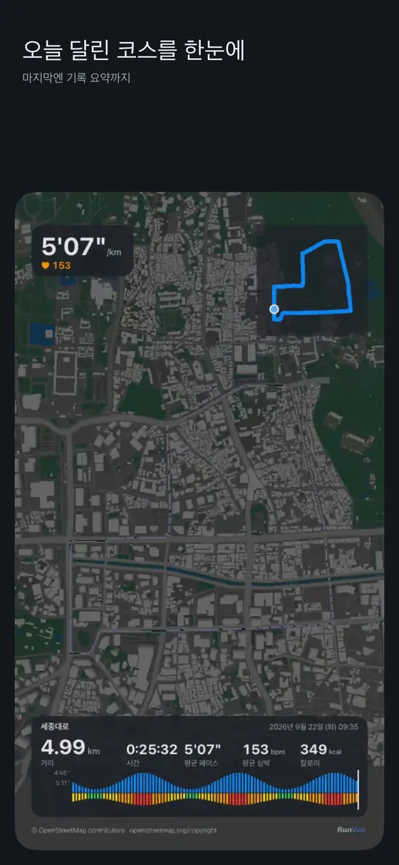
RunVue는 이미 기록된 러닝을 짧은 3D 리플레이 영상으로 바꿔 주는 앱입니다. 러닝 중에 켜 두는 트래커가 아니라, 달리기를 마친 뒤 건강 앱(iPhone의 Apple 건강, Android의 Health Connect)에 쌓인 운동 기록을 불러와 영상으로 만드는 도구입니다. 지도를 하늘에서 내려다보는 대신, 달린 길을 러너의 눈높이에서 따라가는 것이 특징입니다. 기본은 뒤에서 따라가는 추적 3인칭 시점이고, 하이라이트 구간에서는 1인칭 시점으로 바뀝니다. 마지막에는 하늘 시점으로 올라가 전체 코스를 한 번에 보여 줍니다.
이런 분께 맞습니다. 달린 코스를 기록으로만 두기 아쉬운 분, 스마트워치 화면 캡처 대신 조금 더 기억에 남는 형태로 러닝을 공유하고 싶은 분, 같은 코스를 반복해서 달리며 변화를 영상으로 모아 두고 싶은 분입니다. 반대로 실시간 음성 안내나 훈련 계획이 필요하다면 이 앱의 역할이 아닙니다. 그런 용도는 인터벌 코치 앱이나 시계의 기본 운동 앱이 맡고, RunVue는 그 결과를 보기 좋게 정리하는 단계에 놓입니다.
화면으로 미리 보기
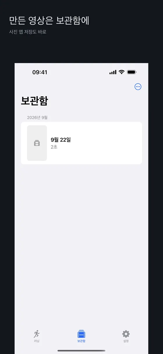
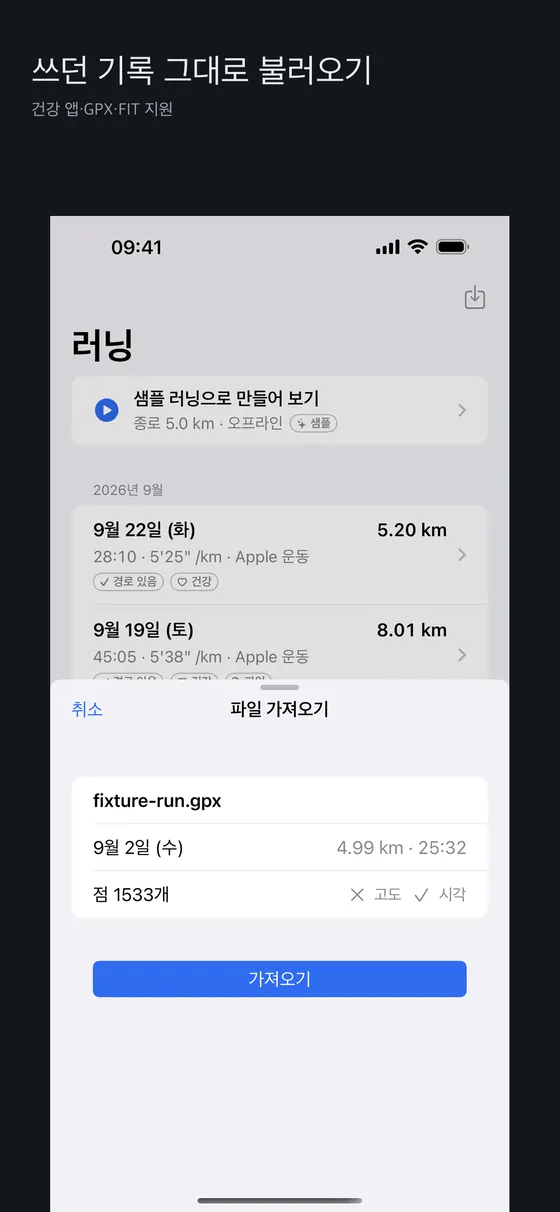
아래 다섯 장은 iPhone 화면입니다. 영상 장면 두 장, 설정, 보관함, 가져오기 순서입니다.
시작하기 전에 필요한 것
- 위치 경로가 포함된 러닝 기록. 야외에서 GPS를 켠 상태로 기록한 러닝이어야 합니다. 러닝머신이나 실내 운동은 경로가 없어서 3D로 따라갈 길이 없습니다.
- 건강 앱 읽기 권한. iPhone에서는 Apple 건강, Android에서는 Health Connect에서 운동과 심박 같은 데이터를 읽도록 허용해야 합니다. Android에서는 경로 데이터 권한이 별도 화면에서 다시 확인되는 경우가 있으므로, 목록에 러닝은 보이는데 경로가 없다고 나오면 Health Connect 설정에서 경로 허용 여부를 확인해 보세요.
- 인터넷 연결. 지도 타일을 받아 건물과 길을 그리기 때문에, 영상을 만드는 동안 네트워크가 필요할 수 있습니다. 개인 경로는 이 과정에서 서버로 올라가지 않습니다.
- 기기 성능. 3D 렌더링과 영상 인코딩을 기기에서 직접 하므로 오래된 기기에서는 시간이 더 걸립니다. 가능한 한 충전하면서 만드세요.
앱은 iPhone과 Android 모두 스토어에 등록되어 있지만, 지원 OS 버전과 지역별 제공 여부는 각 스토어 상세 페이지의 정보가 기준입니다. 설치 전에 한 번 확인해 보세요.
영상 만드는 순서
- 권한 허용. 처음 실행하면 건강 데이터 읽기 권한을 묻습니다. 앱이 읽는 항목은 운동 기록과 경로, 심박 등 영상에 필요한 것들로 제한됩니다. 생년월일이나 체중은 수집하지 않고, 최대 심박수는 고정값을 쓰며, 칼로리는 기록에 있으면 그 값을, 없으면 거리 기반 추정치를 물결표(~)와 함께 보여 줍니다.
- 러닝 고르기. 목록에서 영상으로 만들 러닝을 선택합니다. 아직 러닝이 하나도 없다면 샘플로 먼저 어떤 결과가 나오는지 볼 수 있습니다.
- 미리보기. 추적 카메라가 경로를 따라가고, 화면에는 페이스와 심박이 표시되는 HUD, 우측 상단 미니맵, 구간 정보가 나옵니다. 영상 길이는 달린 거리에 따라 22초, 27초, 32초 중 하나로 정해지는 세로(9:16) 영상입니다.
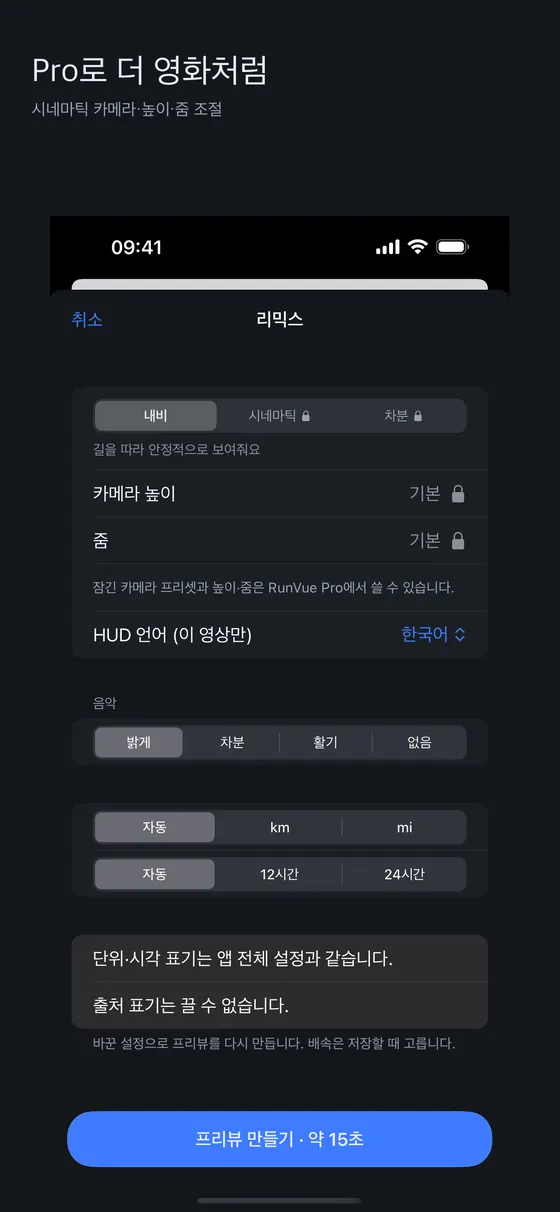
- 시점과 배속 조정. 무료로는 기본 내비 카메라와 1배속 요약 영상을 만들 수 있습니다. 2배속에서 60배속까지의 배속, 시네마틱·차분 카메라 프리셋, 카메라 높이와 줌 조절은 구독(Pro) 기능입니다. 시스템에서 동작 줄이기를 켜 둔 경우에는 차분 프리셋을 무료로 쓸 수 있게 되어 있습니다.
- 저장과 공유. 완성된 영상은 사진 앱에 저장하는 것이 기본이고, 시스템 공유 시트로 다른 앱에 보낼 수도 있습니다. 모든 영상에는 앱 워터마크가 들어갑니다. 지도 데이터 출처(OpenStreetMap) 표기도 영상 시작과 엔딩에 포함됩니다.
공유 전에 꼭 확인하세요. 영상은 출발부터 도착까지 전체 경로를 그대로 보여 줍니다. 집에서 출발해 집으로 돌아왔다면 집 위치가 노출될 수 있습니다. 공개 계정에 올리기 전에 경로 시작과 끝이 어디인지 확인하고, 필요하면 비공개 친구에게만 보내세요.
화면 읽는 법
HUD
상단의 페이스 배지는 해당 시점의 속도를 분/킬로미터 형식으로 보여 주고, 심박 값은 BPM으로 표시됩니다. 하단에는 시간에 따른 속도와 심박 파형이 나와 전체 러닝의 강약을 한눈에 볼 수 있습니다. 파형은 무료로 제공됩니다. 직선 구간은 빠르게, 의미 있는 구간은 느리게 재생하는 가변 속도가 적용되므로 영상 속 시간은 실제 시간과 비례하지 않습니다.
엔딩 화면
마지막 장면은 하늘 시점에서 전체 코스를 훑고, 지도에서 읽어 낸 통과 지점 이름과 러닝 요약을 보여 줍니다. 지명은 기기 언어에 맞춰 표시하려고 하지만, 지도 데이터에 해당 언어 이름이 없으면 기본 이름으로 대체됩니다.
더 좋은 영상을 위한 팁
- 러닝을 시작하기 전에 GPS 신호가 잡힐 때까지 몇 초 기다리세요. 출발 직후 경로가 튀면 영상 초반 카메라도 흔들립니다.
- 고층 건물 사이나 터널이 많은 코스는 경로가 건물 안으로 들어가 보일 수 있습니다. 지도 매칭이 도로로 보정해 주지만 완벽하지 않습니다.
- 심박을 HUD에 넣고 싶다면 심박 센서나 스마트워치로 측정한 러닝을 고르세요. 심박 없이 기록한 러닝은 해당 값이 비어 있습니다.
- 같은 코스를 일정 기간 간격으로 만들어 비교하면 계절 변화나 페이스 차이를 기억하기 좋습니다.
- 영상 생성 중에는 앱을 앞에 두세요. 백그라운드에서 렌더링이 중단되거나 느려질 수 있습니다.
자주 막히는 상황
- 러닝 목록이 비어 있어요. 건강 앱에 러닝이 실제로 저장되어 있는지, 앱에 읽기 권한을 줬는지 확인하세요. 시계의 운동 기록이 건강 앱에 동기화되기까지 시간이 걸리는 경우도 있습니다.
- 경로가 없다고 나와요. 실내 운동이거나 위치 권한 없이 기록한 러닝입니다. 다른 러닝을 선택하세요.
- 지도가 단순하게 보여요. 지도는 OpenStreetMap 기반이라 지역에 따라 건물 높이 정보가 부족할 수 있습니다. 이 경우 평균적인 높이로 대신 그립니다.
- 영상 생성이 오래 걸려요. 기기 온도와 남은 저장 공간을 확인하고, 다른 무거운 앱을 닫아 보세요.
개인정보와 데이터
RunVue는 계정을 만들지 않으며, 러닝 경로와 건강 데이터는 기기 밖으로 나가지 않도록 설계되어 있습니다. 서버는 지도 타일 같은 정적 파일만 제공하고, 개별 요청 로그를 남기지 않는 것을 원칙으로 합니다. 자세한 내용은 개인정보 처리방침을 참고하세요. 구독 결제는 각 스토어가 처리합니다.
한계와 알려진 이슈
- 이미 기록된 러닝만 영상으로 만듭니다. 실시간 트래커나 훈련 코치가 아닙니다. 경로(GPS)가 있는 야외 러닝이어야 하고 러닝머신·실내 기록은 따라갈 길이 없습니다.
- 워터마크와 지도 출처 표기를 끌 수 없습니다. 무료와 구독 모두 앱 워터마크가 들어가고, 지도 데이터(OpenStreetMap) 표기도 라이선스상 영상에 포함됩니다.
- 전체 경로가 그대로 보입니다. 집에서 출발해 돌아온 러닝이라면 집 위치가 드러날 수 있고, 앱에는 구간을 가리는 기능이 없습니다. 공유 범위를 직접 관리하세요.
- 지도 품질은 지역에 따라 다릅니다. 건물 높이 정보가 부족하면 평균 높이로 대신 그립니다. 고층 건물 사이나 터널이 많은 코스는 경로가 건물 안으로 보일 수 있습니다.
- 영상 길이는 거리에 따라 22초, 27초, 32초 중 하나입니다. 영상 속 시간은 가변 속도라 실제 시간에 비례하지 않습니다.
- 기기 성능과 열에 민감합니다. 3D 렌더링과 인코딩을 기기에서 직접 하므로 오래된 기기에서는 오래 걸립니다. 생성 중에는 앱을 앞에 두고 충전하면서 만드세요.
- 무료 범위가 제한됩니다. 1배속 요약과 내비 카메라, 파형은 무료이고, 배속 변경·시네마틱 카메라·높이·줌은 구독(Pro)입니다. 스크린샷의 GPX 가져오기는 iPhone 화면 기준이며, Android 앱의 지원 범위는 스토어 설명을 확인하세요.
다른 방법과 비교
| 방법 | 강점 | 약점 |
|---|---|---|
| RunVue 3D 리플레이 영상 | 내 시선으로 따라가는 영상, 페이스·심박 표시, 기기 안 처리 | 경로가 그대로 노출, 워터마크, 생성에 시간이 걸림 |
| 시계·러닝 앱의 요약 이미지나 지도 캡처 | 빠르고 가벼움, 거리·시간이 한눈에 | 정적인 이미지라 흐름은 담기 어려움 |
| 화면 녹화 | 추가 앱이 필요 없음 | 지도 화면 그대로라 몰입감이 낮고 편집이 필요 |
공유 전략과 안전 수칙은 러닝 영상 가이드에서 다룹니다.
자주 묻는 질문
러닝 기록은 RunVue에서 직접 측정하나요?
아니요. 건강 앱에 이미 저장된 기록을 불러와 영상으로 만듭니다. 측정은 평소 쓰는 시계나 러닝 앱이 하면 됩니다.
다른 러닝 앱의 기록도 쓸 수 있나요?
해당 앱이 건강 앱(Apple 건강 또는 Health Connect)에 러닝을 저장하도록 되어 있어야 합니다. 저장하지 않는 앱의 기록은 목록에 나타나지 않습니다.
무료로 어디까지 쓸 수 있나요?
1배속 요약 영상, 내비 카메라, 속도·심박 파형이 무료입니다. 배속 변경, 추가 카메라 프리셋, 높이·줌 조절은 구독이 필요합니다. 가격과 체험 조건은 결제 화면과 스토어에 표시된 내용이 기준입니다.
워터마크를 없앨 수 있나요?
무료와 구독 모두 워터마크가 들어갑니다. 지도 출처 표기도 라이선스상 영상에 포함됩니다.
내 집 위치를 가릴 수 있나요?
영상은 전체 경로를 보여 주므로 앱 안에서 구간을 가리는 기능은 없습니다. 공유 범위를 직접 관리해 주세요. 방법은 러닝 영상 가이드에서 더 자세히 다룹니다.
GPX 파일도 쓸 수 있나요?
iPhone 앱 화면에는 GPX 파일 가져오기가 있습니다. 건강 앱에 경로를 쓰지 않는 기기의 기록을 위한 방법입니다. Android 앱의 지원 범위는 스토어 설명에서 확인하세요.
영상 생성에 얼마나 걸리나요?
설정 화면에는 프리뷰 만들기가 약 15초로 안내되며, 실제 시간은 기기 성능과 온도에 따라 달라집니다. 생성 중에는 앱을 앞에 두세요.
도움이 더 필요하면 지원 페이지를 이용해 주세요.
What RunVue does
RunVue turns a run you have already recorded into a short 3D replay video. It is not a live tracker you start before heading out. Instead, you finish your run with your watch or favorite running app, and RunVue reads the workout from the health store on your phone (Apple Health on iPhone, Health Connect on Android) and renders a video. Rather than a bird's-eye map, the video follows your route at runner height. The default camera chases from behind in third person, switches to first person during highlight sections, and finally rises to a sky view that shows the whole course.
It suits people who want to share a run in a more memorable form than a screenshot of a watch screen, and people who like keeping a visual log of a favorite route. It is not a coaching tool: if you want live voice cues or structured training, use a coach app or your watch's workout app, and let RunVue present the result afterwards.
Screens at a glance
The five images below are iPhone screens: two video scenes, then settings, library and import.
What you need
- A run with a location route. The workout must have been recorded outdoors with GPS. Treadmill and indoor workouts have no route to follow.
- Health data read access. Allow the app to read workouts and heart rate from Apple Health or Health Connect. On Android, the route permission is handled on a separate screen; if a run appears in the list but is reported as having no route, check the route permission in Health Connect settings.
- A network connection. Map tiles are downloaded to draw buildings and roads, so rendering may need internet access. Your personal route is not uploaded in the process.
- A reasonably capable device. Rendering and video encoding happen on the device itself, so older phones take longer. Plugging in while you export is a good habit.
The app is listed on both the App Store and Google Play. Supported OS versions and regional availability are shown on each store page, so check there before installing.
Making a video, step by step
- Grant permission. On first launch you are asked for read access to health data. The app limits itself to what the video needs: workouts, routes, and heart rate. It does not collect your birth date or weight. Maximum heart rate uses a fixed value, and calories come from the recorded value when available or an estimate shown with a tilde (~).
- Pick a run. Choose a workout from the list. If you have no runs yet, you can try a sample to see what the result looks like.
- Preview. The chase camera follows the route while the HUD shows pace and heart rate, with a mini map in the top right and section information. Videos are vertical (9:16) and run 22, 27 or 32 seconds depending on the distance you covered.
- Adjust view and speed. For free you get the default navigation camera and a 1x summary video. Playback speeds from 2x to 60x, the cinematic and calm camera presets, and camera height and zoom controls are part of the subscription (Pro). If Reduce Motion is enabled in your system settings, the calm preset is available at no charge.
- Save and share. Saving to your Photos library is the primary route, and you can also send the file to other apps through the system share sheet. Every video carries the app watermark, and map data attribution (OpenStreetMap) appears at the start and in the ending.
Check before you share. The video shows your route from start to finish. If you left from home and came back to it, the video can reveal where you live. Before posting publicly, look at where the route begins and ends, and consider sending the clip only to people you trust.
Reading the screen
The HUD
The pace badge at the top shows speed as minutes per kilometer, and heart rate appears in beats per minute. A waveform of speed and heart rate along the bottom summarizes the effort of the whole run, and it is free. Playback uses variable speed: straight stretches pass quickly while notable sections slow down, so time in the video is not proportional to real time.
The ending
The last scene sweeps the full course from above, lists place names the route passed, and shows a short run summary. Place names try to follow your device language, but fall back to the default name when the map data has no translation.
Tips for better results
- Wait a few seconds for a GPS lock before you start a run. A jumpy start shows up as a shaky camera at the beginning of the video.
- Courses between tall buildings or through tunnels may look slightly off. Map matching snaps the track to roads, but it is not perfect.
- If you want heart rate in the HUD, pick runs recorded with a sensor or a smartwatch. Runs without heart rate simply show no value.
- Render the same route every few weeks and compare; seasons and pace changes make a nice record.
- Keep the app in the foreground while exporting. Background rendering can slow down or pause.
Troubleshooting
- The run list is empty. Confirm the run is really stored in the health app and that RunVue has read access. Syncing from a watch can take a while.
- It says there is no route. The workout was indoors or recorded without location permission. Choose a different run.
- The map looks plain. Maps come from OpenStreetMap, and building height data is thin in some regions. Average heights are used where data is missing.
- Export is slow. Check device temperature and free storage, and close other heavy apps.
Privacy and data
RunVue needs no account, and it is designed so that your routes and health data stay on your device. The server only provides static map files, and the policy is not to keep individual request logs. See the privacy policy for details. Subscription payments are handled by the respective store.
Limits and known issues
- It only turns already-recorded runs into videos. It is not a live tracker or a coach. The run must be an outdoor run with a GPS route; treadmill and indoor workouts have no path to follow.
- The watermark and map credit cannot be turned off. Both free and subscription videos carry the app watermark, and the map data (OpenStreetMap) credit is included for licensing reasons.
- The whole route is visible. A run that starts and ends at home can reveal where home is, and the app has no feature to mask a segment. Manage who you share with yourself.
- Map quality varies by region. Where building height data is missing, an average height is drawn instead. Courses among tall buildings or with many tunnels can show the route passing through buildings.
- Video length is one of 22, 27 or 32 seconds depending on distance. Time in the video uses variable speed, so it is not proportional to real time.
- It is sensitive to device performance and heat. 3D rendering and encoding happen on the device, so older devices take longer. Keep the app in front and charge while it renders.
- The free range is limited. The 1x summary, Navi camera and waveform are free; changing speed, the cinematic camera, height and zoom need the subscription (Pro). The GPX import in the screenshot is from the iPhone app; check the store description for what the Android app supports.
How it compares
| Method | Strength | Weakness |
|---|---|---|
| RunVue 3D replay video | A first-person-style video, pace and heart rate shown, processed on-device | Route fully exposed, watermark, takes time to render |
| A summary image or map screenshot from your watch or running app | Fast and light, distance and time at a glance | A still image cannot carry the flow of the run |
| Screen recording | No extra app needed | Plain map screen is less immersive and needs editing |
Sharing strategy and safety tips are in the running replay video guide.
FAQ
Does RunVue record my run?
No. It imports runs already saved in your health app. Use your usual watch or running app to track.
Can I use runs from other running apps?
Only if that app writes its runs into Apple Health or Health Connect. Runs that are not stored there will not appear.
What is free?
The 1x summary video, the navigation camera, and the speed and heart rate waveform are free. Speed changes, extra camera presets and height and zoom controls need the subscription. Prices and trial terms are whatever the payment screen and store listing show.
Can I remove the watermark?
No, it appears for free and Pro users alike, and the map attribution is required by the data license.
Can I hide my home location?
The video shows the full route and the app has no feature to mask sections, so manage who sees the clip yourself. The running video guide covers this in more depth.
Can I use GPX files?
The iPhone app has a GPX import screen, meant for devices that do not write routes to Health. Check the store description for what the Android app supports.
How long does it take to make a video?
The settings screen says about 15 seconds to make a preview; actual time depends on the device and its temperature. Keep the app in front while it renders.
If you need more help, visit the support page.